

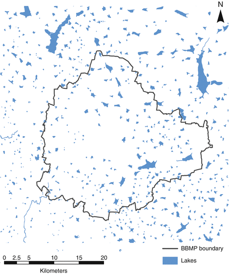
In an area of pronounced water scarcity high on the Deccan plateau, at an altitude removed from river-water and of water extraction from the ground, despite being historically nourished by monsoons, Bangalore's current population faces deep inequities of access to water which are difficult to capture in data or adequately convey. The map I drafted with cartographer Maël Le Noc charts the story of the city lakes that have gained attention of environmental science, in public-private schemes, neoliberal programs, and community movements, framing the meaning of access to the lakes in a Guerrilla Cartography that begins from the ground.
Bangalore’s Disappearing Lakes maps the centrality of water in the city’s physical and spiritual landscapes, and how these landscapes are historically connected. Prepared for Guerrilla Cartogaphy’s Water Atlas, the map combines three information layers, which are often separated in maps of water scarcity, to describe changes in an urban landscape that was once rich with water, but is now under the huge pressures of climate change and population growth. These layers are landcover change, vanished and compromised lakewater, and religious processions that celebrate a city once boasting a “necklace of lakes.” Together, these three layers track an existential rewriting of human relations to water.
The rainwater-dependent lakes, built in the sixteenth century, were long a basis for neighborhoods, and were maintained by resident custodians who inherited the office. Minimal urban oversight or regulation on development, however, encouraged an over-paved city, compromising the often-seasonal network of lakes, which were formerly connected by underground canals in an artificial watershed, and removed them from groundwater recharge. Bangalore’s rapid expansion has challenged local hopes for environmental restoration of walled tanks and miniature reservoirs, which began in the early 2000s. A crisis of drinking water, stench of refuse, and industrial pollutants place problems of local restoration on Bangaloreans’ front plate.
Modern Bengaluru (aka Bangalore) today faces many forms of water stress — soil subsidence, water pollution, flooding of residential neighborhoods, poor infrastructure, and difficulties of water distribution. Poor environmental safeguards have let surviving lakes foam over with industrial byproducts that rise onto their surfaces or combust in flames, and their catchments are greatly contracted by residential expansion and landcover change. Still, it remains difficult to obtain accurate public data on the purity of water or water safety, the precarity of drinking water supplies, and groundwater and urban pollution.
In the context of a broad crisis in groundwater supplies across India — Bengaluru, Delhi, Chennai, and Hyderabad are poised to exhaust water supplies by 2020 — the lost landscape of lakes poses poignant problems in this plateau city removed from rivers, whose early rulers long relied on tanks to harvest water for agriculture. Most of the larger lakes exist outside the city center, and most of those are polluted by untreated sewage or industrial run-off.
“Bangalore’s Disappearing Lakes” maps the filled-in and polluted tanks used for rainwater harvesting (each shown by a marker evoking mourning of their loss) against a ritual procession, called the Karaga, which links sites of traditional tanks in the increasingly paved center of this South Asian megacity. The lakes orient the Bengaluru Karaga procession, held each year at the first full moon of the Hindu calendar. The procession links a religious diversity of Hinduism in Karnataka Province — including Bhakti and Vedanta Hinduism — with Muslims, Buddhists, Jains, Thigala, and Christians. This urban ceremony transcends religious divides by uniting the city around a shared symbolism, tapping public memory of a past geography of lakes that recalls a lost centrality of water in the city, of lakes long used by cleaning people, for laundry washing, and by fishermen. Will this ritual survive the encroachment or disappearance of once-healthy water bodies and paving of lakebeds?
The map-making process
Uniform data, whether on water pollution, or on lake-use for washing and feeding cattle, fishing, and clothes washing, or on religious celebrations at lakes, was sadly difficult to obtain. Lake-loss became a proxy to trace a shifting relation to an urban space where tanks held monsoon water in Bangalore’s celebrated “necklace of lakes.” The current lakes — or tal — are sites of an agrarian past, with fifty “healthy” tanks peeking through the paved landscape as historical vestiges; the shallowest lakebeds, like Sampangi Lake, barely exist today. Projects to pipe water from the Cauvery River, 100K distant, via pipelines to urban reservoirs below the plateau city, cast the lakes as an unwanted agrarian inheritance.
In an area of pronounced water scarcity high on the Deccan plateau, at an altitude removed from river-water and of water extraction from the ground, despite being historically nourished by monsoons, Bangalore's current population faces deep inequities of access to water which difficult to capture in data or adequately convey. The map I drafted with cartographer Maël Le Noc charts the story of the city lakes that have gained attention of environmental science, in public-private schemes, neoliberal programs, and community movements, framing the meaning of access to the lakes in a Guerilla Cartography that begins from the ground.
We hoped to map the performative relation of urban residents to this landscape by the route of the annual Karaga, a procession that affirms the continued identity of the city even in the face of the drying of its environment. We began with the problem of mapping water scarcity, but were attracted by data-maps of lakewater and landcover that track a human story of drastic landscape change, which were mapped in detail by the Centre of Environmental Studies in Bangalore. This national organization is charged with monitoring environmental management, mapping lake loss as a crisis of urban overdevelopment.

Temporal changes in lake-water, greenspace, and land-use, in Bangalore: Land Use Dynamics, figure 3.2. (Courtesy T.V. Ramachandra, Energy and Wetlands Group, Indian Institute of Sciences)
Rendering cumulative lake-loss in one map, we evaluated how best to map the human relation to the tragedy of declining quality of bodies of water once designed for rainwater harvesting. The waters stored in the tal of early modern Bengaluru contain a deeper spiritual meaning, following the Punjabi Rig Veda’s personification of water, orienting believers to “help us find the life force.” The Bengaluru lakes were personified as sites of deities in the annual ritual of the Karaga procession, in which all the city’s faiths partake.
The Karaga begn with a ritual immersion in Bellandur Lake, then proceeded to visiting fragmentary lakes as sites of worship, veneration, and human contact with the divine. Among a graveyard of lakes and obstructed, polluted impounded canals, we mapped a prominent red ring at the city center, activating a deep history of the tanks, in the face of a broader regional crisis of groundwater supply, evident in dried urban lakebeds.
In early modern Bengaluru, the tal had responded to a tremendous series of droughts, and we map the disequilibria of these man-made bodies of water as a condensation of the problems of global warming. The tal are valued by multiple faiths as sites of contact with and access to sacred renewal, even in an era of radical water scarcity. These trenches of land, impounding water for year-round supply, and once the structure for husbandry, washing, and drinking, were also sites symbolizing rejuvenation, reminding residents of the biological reciprocity of the lakes, the annual rains, the lived environment, and the nourishment of the city.
In ways that LiDar or GoogleMaps georeferencing cannot record, we map the lost lakes from a humanistic perspective that compliments but also goes beyond records of the quantitative loss of water bodies or acreage of water. Despite limited data of the loss of such sites of rainwater retention, a historic baseline of 262 lakes — of which 46 were eradicated — remain the waypoints for expressing public devotion during the still-vibrant annual ritual of Karaga.
The procession presents a counter-map of the draining, pollution, and paving of lakes once central to urban life. The annual devotion to the lakes at the first full moon of the Hindu calendar occurs against a backdrop of vanishing lakes and tanks, affording a restoration of human-sacred relations of cosmological import in the face of global warming and endemic drinking water shortages. Lake sites still provide access to the divine, even as recently urbanized areas on the periphery have become polluted with industrial effluent, domestic waste, and runoff.
With urban development, the paving of lakes in central Bengaluru transformed a landscape rich with water into one threatened by flooding, pollution, and disrupted ecosystems. The crisis of water created by limited groundwater compromised urban residents’ historical relation to an interlinked system of lakes that now regularly overflow, shrink to bogs clotted with weeds, and where flammable industrial runoff regularly catches fire. From the 1950s on, impounding the monsoon water was seen as an atavistic survival from an agrarian, non-modern past. The catchments were drained, and were repaved for public spaces as stadiums and bus terminals. Fewer walled tanks, long repositories of domestic water, dried an urban center; these are rendered in the map in warm oranges and yellows.
The map illustrates the increasingly tenuous place of such bodies of water in the modern city. We reveal the accelerated disappearance of the lakes in the once-irrigated city with geolocated ‘x’s. We opted not to trace a trajectory of historical transformation of the city’s irrigation system. We wanted instead to suggest the once-plentiful sites of access to the sacred in the city’s delicate ecology, and the fate of lakes in a built environment by the possibility for their ritual survival, and how those lakes continue to serve as access to the divine, even as their volumes and purity decline.
We questioned whether shape-files satisfactorily depicted water bodies, registering on Google Earth as of 2016 by a uniform bright blue, without noting effects of increased domestic and industrial waste or the overbuilt setting.
Distribution of lakes within and surrounding Bangalore. Note the lack of lakes in the city center, indicating their encroachment and conversion to other land uses (Prepared by and published with kind permission of © Harini Nagendra 2012. All Rights Reserved) (https://link.springer.com/chapter/10.1007/978-94-007-7088-1_7, fig 7.2)
By designating vanished lakes regardless of size by a simple ‘x’ we map the loss of lakes against urban growth.
As we enter the twenty-first century, overbuilding of the urban center with impermeable landcover has obscured Bengalureans’ relations to the sacred cycle of monsoon rains, which situates the annual Karaga ritual. The continuation of this procession, in a celebration of water’s abundance, juxtaposes the subjective experience of the festival in the urban center against the disappearance of its lakes. The annual ritual of Karaga proceeds in a fixed route as if to reconstitute the lost “necklace of lakes” for which the city is historically celebrated. We lend centrality to Karaga in our map by bright red, to suggest the vitality of the annual procession in which much of the city participates. Among a graveyard of old and obstructed lakes, trenches of land once refilled by monsoons, we map a prominent red ring at the city center as activating a deep history of water in an ecosystem of seasonal rejuvenation.

Route of the Karaga procession
We provide local context through inset views on the map of three sacred lakes. Views of two of the more aestheticized urban lakes — Hebbal Lake and Bellandur Lake — reveal their dramatically reduced size and an almost entirely reduced bed of Sampangi Lake. These views point out radical constraints on water reserves, which had long been points of urban orientation, habitats for a huge variety of birds, and a respite from heat.
Bangalore’s lakes’ shrinking surfaces are often mapped against increased pollution, clotting by sediment and weeds, lowering water table, or decreased habitat. As Guerilla Cartographers we chose to focus on the public spaces lakes still offer — places that long defined the commons and the sacred.
In the Karaga procession, we see resistance to a decaying infrastructure. Against a grim image of the dearth of lakes that were overbuilt with urban growth, sites of vanished or diminished lakes retain considerable significance. Red dashes in our map situate the Karaga procession among lakes, even as unregulated urban expansion makes inroads into lake catchments. The map explores conundrums that citizens face, orienting themselves to an increasingly lake-less landscape and compromised spiritual landscape in the former Garden City. We imagine celebrants moving between surviving, reduced, and vanished lakes, creating meaning in an increasingly over-paved city, amidst shrunken lake catchments where the physical contours of the lakes are continually redesigned as unsupervised construction proceeds.